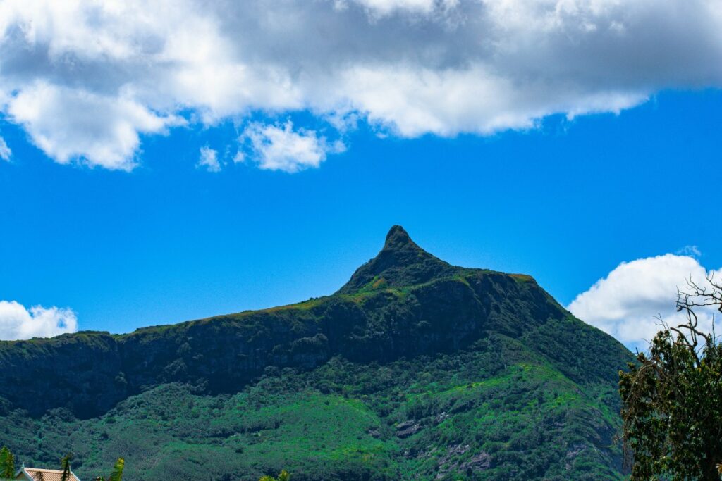
There are no skyscrapers on Mauritius island with observation decks and panoramic views on the city. Instead of this, there are many hiking trails in Mauritius that will allow you to climb one of the island’s mountains, the views open from the summit will be stunning and will be worth all your efforts. Start your exploration with hiking Le Pouce mountain.
Read this post to get detailed information about hiking Le Pouce mountain; learn more about day tours, best time to hike, trails and other useful tips for first timers.
Le Pouce Mountain General Info
- Height 821 meters
- Time required up to 4 hours, depending on your physical fitness level
- Difficulty moderate
For those, just arrived in the capital of Mauritius island – Port Louis, hiking Le Pouce mountain can be a great start to explore the country. There are actually two paths for hiking this mountain. Let’s check both of them so you can decide later which one is the best for you. Even though hiking Le Pouce mountain can be tricky in some parts, it’s considered one of the easiest.
Hiking Le Pouce from the north
You can start your ascent from Port Louis. This path is the best option for those looking for some privacy while climbing, as guides mostly suggest making your choice in favor of the route that starts from Moka village.
Your trip will go through Le Dauguet and will be longer compared to the more traditional way via St Pierre. In order not to get lost on your way, keep an eye on painted stones along the way. In several places there will be an opportunity to choose your way, always keep to the left in order not to go astray.
If you did everything right, further you’ll see mango trees and finally the sign telling which direction to follow before you reach the summit. Once you are on the main trail, just try to follow it. In some places it can be a bit confusing, which path to choose. You should know that all of them will lead you to the peak anyway.
Hiking Le Pouce from the south
This route is the one preferred mostly by tourists and local visitors as well. Journey will start from Moka village, which is a 27 km drive to the south from Black River Gorges – one of Mauritius national parks. In the village you’ll see signs telling you which directions to follow for hiking Le Pouce mountain. Firstly, the road goes through the sugarcane fields. This is an asphalt road, so if you’re traveling by car you can easily ride a certain part of the way.
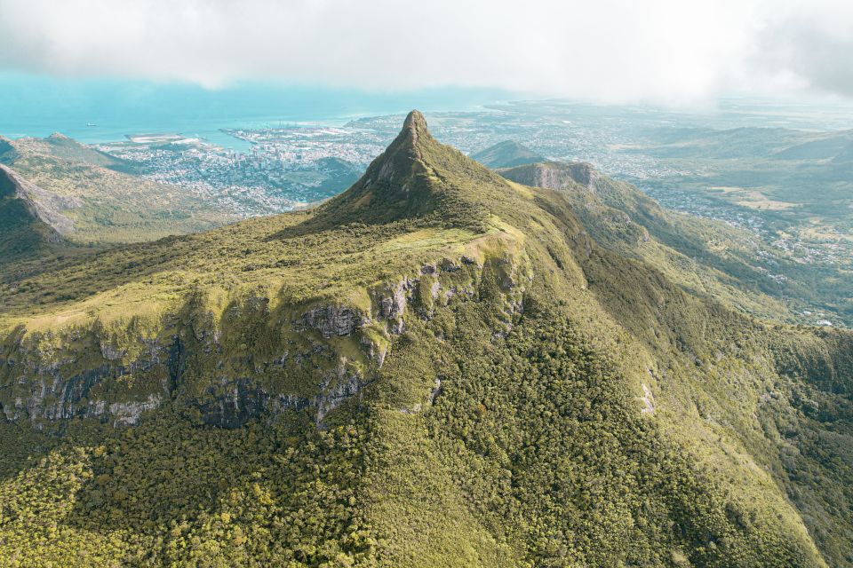
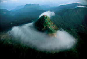
Le Pouce Mountain Summit
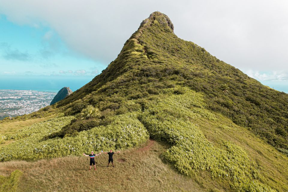
Once northern and southern paths are united you need to make some efforts to reach the top of the mountain. There are actually several viewpoints at Le Pouce Mountain, but the coolest views are from the summit. Be ready to use your hands, this is a necessary precaution, as the climb is quite steep there. It can take about 20 minutes to climb to the top. Since the top of the mountain is quite narrow, no more than 15 people can be on it at the same time. Panoramic views on Port Louis and Beau-Bassin Rose-Hill are really fantastic.
The wind on the top of the mountain is really strong, even when there are no clouds on the horizon and the sun is shining brightly. Make sure to take warm clothes with you, also to make hiking Le Pouce mountain more comfortable wear appropriate trekking shoes.
Be super careful while descending, as it’s always more complicated compared to ascent. Once you reach the plateau in front of Thumb Mountain, your way will be easier and more relaxed.
If you would like to join Le Pouce Mountain hiking tour, click here to make your reservation.
How to explore Le Pouce Mountain
You can climb the mountain on your own. It’s better to get as much details about the place as possible in advance. Another option is to find local guides in towns or villages from where you’re going to start your trip to Le Pouce peak.
If the above doesn’t suit your needs, you can join a group tour. Hiking starts from Moka, with preliminary instructions about all possible dangers. There will be enough stops to make nice photos, so make sure your camera is charged well.
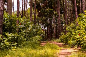
The goal is not only to reach the highest viewpoint at Le Pouce mountain, but to enjoy the trail itself as flora is diverse along the way. You can see guava trees, palms, and acacia. It’s also the only place where you can see rare endemic Bois Dentelle – Elaeocarpus bojeri. This plant can be found in some of the nature reserves in Mauritius island.
Le Pouce Mountain Video
FAQ
It can take about 2 hours to climb if you’re going to follow the most popular among visitors hiking trail that starts in St Pierre.
It is located in the center of Mauritius island in the village of Petit Verger Saint Pierre. It will take less than one hour to reach this mountain from any part of the island.
It depends on where you’re going to start your climbing. If you’re planning to hike from Port Louis, it will be rather challenging, and from St Pierre it will be moderate.
Charles Darwin was the first person climbed Le Pouce mountain in Mauritius.
Being 812 meter high, Le Pouce mountain is the third highest peak one in Mauritius.